Instructor: Albert Chao
ARC 617
Fall 2020
DESCRIPTION:
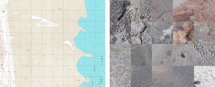
The map (left) is a familiar cartographic representation of the mud flat of the Great Salt Lake. Lines define and delineate the topography of the landscape. A cartesian grid provides scale and location. There are distinct boundaries between land and water. Notable also are three small labels “MUD” that merge all distinct landscape features into one homogenous extent. Karen Lutsky and Sean Burkholder offer a different understanding of the landscape (right). They propose a practice that “probes as opposed to proves”, and centers curiosity, openness, and exploration as they physically engage and traverse the landscape. They document their explorations and meanderings through a series of photographic images and collages as they walk the terrain.1
The ambition of the course builds on this approach of probing to engage with contemporary mapping technology. As the ubiquity of digital tools increasingly governs, regulates, and impacts our daily movement through space, tools built using computer code have become intertwined with larger systems of daily life. These technologies have reinforced and reframed design issues that include inclusive design, ecological practices, urban design, and material culture. If given the tools to engage our digital trace through physical space, how can we explore and expand our conception of the map? As designers, what agency do we have in our digital, physical, and social spaces? How do we understand and engage this complexity?
This class is divided into three parts. Part I, students will draw an object from their daily lives with code. In the process, we will design dynamic graphic representations that will explore abstraction, interaction, and mapping. Part II, we will learn to collect GPS data. Students will assess, design, and draw their digital traces through physical space. This part culminates in a remote collective walk. For the final part of the class, students will work in groups to develop a self-directed project. Projects can be whimsical, ecological, socio-political, abstract, and/or performed. Together, we will interrogate, redraw, and reconceive maps to probe the urban fabric. How can these tools be repurposed for play and interaction within digital and physical space? How can we orchestrate, perform, and challenge our understanding of daily life?
1. Karen Lutsky and Sean Burkholder. “Curious Methods.” Places Journal. May 2017